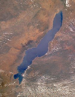
Malawi’s absurd claims that the whole of Lake Nyasa, or as they stubbornly call it Lake Malawi, belongs to it did not start today. This is an inherited problem from the British who kept changing the borderline to suit their colonial ambitions. Sadly, Malawians think they are still under the British.
Malawi, formerly Nyasaland, bases its argument on the Anglo-German Agreement of 1890, and conveniently hiding behind a 1964 resolution of the now defunct Organization of African Unity without even knowing its genesis. The resolution, which follows a principle in international law called uti possidetis, ita possidetis, meaning, “may you continue to possess such as you do possess”, was updated in 2002 and 2007 by the African Union.
That resolution was a brainchild of the first president of the United Republic of Tanzania, Mwalimu Julius Nyerere, and it stipulated that African countries must accept the borders as they are. Why Nyerere? The whole story is in one chapter authored by the late Prof. Haroub Othman in the book Reflections on Leadership in Africa: Forty Years After Independence, published in 2000.
Nyerere recounted the visit that Dr Hastings Kamuzu Banda paid him in early 1962, just a few weeks after Nyerere had resigned as Prime Minister of the then Tanganyika. He said: “So Banda comes to me with a big old book, with lots and lots of maps in it, and tells me, “Mwalimu what is this, what is Mozambique, there is no such thing as Mozambique”. I said “What do you mean there is no such thing as Mozambique”. So he showed me this map, and he said “That part is part of Nyasaland, “that part is part of Southern Rhodesia (Zimbabwe), that part is Swaziland, and this part, which is the northern part, Makonde part, that is your part.”
Nyerere continued: “So Banda disposed of Mozambique just like that. I ridiculed the idea, and Banda never liked anybody to ridicule his ideas. So he left and went to Lisbon to talk to Salazar about this wonderful idea. I don’t know what Salazar told him…So those three, the delegation of the Masai, led by the American missionary, Banda’s old book of maps, and the Ogaden, caused me to move that Resolution, in Cairo in ’64.” Banda later became the first president of Malawi.
Nyerere was not wrong, and with regard to Lake Nyasa, he had started the discussion even before Tanganyika and Malawi became independent. On November 30, 1961, as Prime Minister, Nyerere wrote to the Secretary General of the then United Nations Organization (UNO), informing him that Tanganyika would only honor agreements that the British entered on behalf of Tanganyika in the previous two years until December 8, 1961, unless there were further arrangements. Nyerere reasoned that, the British ruled Tanganyika under the terms of a trusteeship, which denied them legal powers to alter borders.
But Malawi’s cabinet crisis in 1964 forced some politicians including a popular nationalist, Kanyama Chiume, by then a foreign affairs minister, to escape to Tanzania through Lake Nyasa, and that outraged Banda. Additionally, Tanzania as the leading country in Africa’s independence struggles couldn’t tolerate Banda who had made himself a South African puppet; thus, the border talks stalled but a cold war emerged.
Later, on May 31, 1967 while speaking in Iringa Nyerere said: “I am told that the boundary was changed by the British during the declaration of the Rhodesian Federation, but they had no right whatsoever to do this because Tanzania (Tanganyika) was a Trust Territory.” Chiume, who studied in Tanzania before going to Uganda to attend Makerere University, was the credible informant on this particular detail.
Chiume had told Nyerere that in 1956 when the British formed a commission to determine borders of the Rhodesian Federation, which would have included Malawi, Zambia and Zimbabwe of today, they moved the borderline from the middle of the lake to the eastern shore. In August 1969 Chiume repeated the same account to James Mayall, a researcher from the London School of Economics.
Banda’s madness didn’t end with the lake; he claimed Njombe, Songea and Tukuyu as part of Malawi, and in response Nyerere said in September 1968: “Banda must not be ignored simply because he is insane.” In fact, Nyerere saw the claims that the border lies alongside the shore was so fooling, that he said: “The insanity of the claim is proved by the fact that the eastern shore is constantly mobile.”
Honestly, it is true that the 1890 Agreement established the border between Nyasaland and Tanganyika on the eastern shore of the lake, but was later redrawn by the British in 1922 when they ruled both countries after World War I. Perhaps, in respect of the riparian water rights, which originate from the English common law, the British moved the border to the midline of the lake, a perfect, logical and legal step since Tanganyika was their mandated territory as directed by the League of Nations.
In 1945, after World War II, Tanganyika continued to be under the British but under different terms of the UNO called trusteeship, meaning Tanganyika would in no way be their colony. The British went back to the 1890 borderline, making an illegal decision in 1956 through a border commission of the Rhodesia Federation, and that is why Malawi’s claims are contested by Tanzania.
In any case, Tanzania’s diplomatic note dated January 3, 1967 remains an official policy even today: “We wish to inform the Government of Malawi that Tanzania has no claim over the waters of Lake Nyasa beyond the line running through the median of the Lake, and that this line alone was recognized by Tanzania as the legal and just delineation between the countries.”
Based on the situation, Nyerere and his government declared on December 20, 1968: “We will wait for the emergence, in Malawi, of a sensible leader”. President Bakili Muluzi was wise in this matter, and somehow Bingu wa Mutharika, but I am afraid the current leader, Joyce Banda, isn’t. Quarelling with Tanzania is not smart considering many factors especially its military capability.
Perhaps what Mayall predicted in 1973 is correct, that, “Malawi has no alternative, in practice, but to acquiesce in a Tanzanian presence on the Lake. In the absence of major effort by Malawi to control the water level, and to exploit the resources of the Lake in a more thoroughgoing manner than at present (1973), it seems the status quo will persist.” That is why things are hot now!

.jpeg&w=60&q=100&h=60)


.jpeg&w=60&q=100&h=60)


